Hello Tello Pilot!
Join our DJI Tello community & remove this banner.
Sign up

Tracking Voltage on DJI Tello

sarahbradley

Member
Joined
May 18, 2022
Messages
6
Reaction score
0
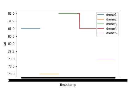
I am currently using 5 DJI Tello Drones to gather data on different drone formations as part of a research project, and we are trying to track their energy consumption. Does anyone know of any way for the drones to send back data on voltage. We've tried plotting battery percentage data but we aren't sure how often the drones update their battery percentage, and the decrease doesn't appear to be consistent across drones. I have included our battery percentage data as an example.

(left diagram: the drones ran for a minute hovering, right diagram: the drones hovered, moved forward by 1 metre, and landed.)
KRbwfPWPngWvnS-D_ZTGabuVvjmBx1ztzG4cWnWg8FzxRHzPC7NX-XT05Wpk6Ce85fjfehWS0tDUdk1WOoyVJSptm8s_lg63M_NAGXrAb_zyG-vAKOz62dmLlCxpgE86nTqGc4NL2lKTchL2Jk-L4g
JxrqDGRzQnzlGKd4hIRa_aVW4Sp7A1s6glZlkpGdfldkcqg-OD0Sg7UpuA6hDJI2FQjyNp7K7HEDrCaJ2VlEPxrzRQgWFvCbRdiOEOZRvNPv3K3tpfG-CAmMQcVueMB3Se2S_krhYxSI2416085ROg

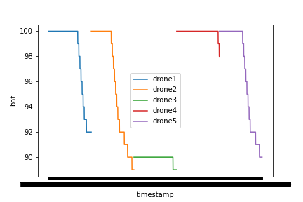
(Each colour is a different drone)
Any feedback would be helpful!

Thank you!
 
Hello We are flying swarms for awhile. Also starting to work on wireless charging. So we would be interested in this data also. Streaming it may be difficult. We are considering hacking a Robolink ZUMI that uses a Raspberry PI Zero, and putting this on the Robomaster TT ( need to lighten the load of the ZUMI componants. ( battery, Raspberry Pi, PI camera, and their board ). intwnd to use their software that can accept Python commands for object recognition.
 
Hello @sarahbradley , Thanks for sharing your work.

I did not yet see a way to get battery voltage through the SDK API, only percentages. May be, you find it in the binary protocol, so perhaps @volate!lo can give further hints.

The percentages are only a rough estimation, as it is difficult to measure state of charge "in flight". They may differ from drone to drone due to tolerances of all components which are involved here.

Another option to get battery voltage would be reading it directly from the battery contacts with little microcontroller like the ESP8266. You can find my light-show extension here, which also contacts directly to the Tello battery: Tello NeoPixel RGBW LED lights add-on, remote controllable, 5g
 
Hello We are flying swarms for awhile. Also starting to work on wireless charging. So we would be interested in this data also. Streaming it may be difficult. We are considering hacking a Robolink ZUMI that uses a Raspberry PI Zero, and putting this on the Robomaster TT ( need to lighten the load of the ZUMI componants. ( battery, Raspberry Pi, PI camera, and their board ). intwnd to use their software that can accept Python commands for object recognition.
Hi Dan,

Thanks so much for your reply!
With your work on swarms, how close are you able to get the DJI Tello Drones to fly from eachother? The closest we can get the drones is 70cm otherwise they crash into one another (especially when flying in wind). We were originally using mission pads however we have found not using the mission pads led to less errors as the drones often struggled to locate themselves relative to the mission pads. If you are able to get the drones to fly closer than 70cm, how did you do this? Thank you :)

From Sarah
 
It works better, when you work with one large map instead of multiple mission pads as shown in this example:


When you use simple positioning commands with absolute coordinates, you may reduce the distance to about 50cm but freestyle figures like the Lissajous curve flown by the formation in that example should use distances of at least 70 cm.

Accuracy also depends on lighting.
Thank you for sharing that with us. Do you know why utilising a floor map would work better than individual mission pads?
Also, we are thinking of utilising the drones velocity to determine how far it's travelled. Have you tried this or know how accurate the velocity of the drones is?
 
Thank you for sharing that with us. Do you know why utilising a floor map would work better than individual mission pads?
Also, we are thinking of utilising the drones velocity to determine how far it's travelled. Have you tried this or know how accurate the velocity of the drones is?
One large map means indicators helping position detection seamless in the whole field of view of the downward facing camera and not only a small portion. It also seems to have an optimized pattern giving more contrast for lower light. Last but not least, you can simply use one coordinate system across the whole map area, which makes programming much simpler.

Regarding the velocity: I think it is only a value that you set via command - not a measured value (which would change during acceleration and braking). It may only give a rough estimation. Also here the map helps through better positional information.
Ah okay. Thank you. We decided to implement Aruco markers so we could cover a larger area as from what we saw the map was approximately 2x2m.
Thank you for clarifying the information about velocity.
 
The map, that I used, ist 4m x 3m and the original file allows up to 5m x 5m.

Aruco markers woul work as well but in that case you'll have no support by Tello itself. Just the video stream. You will have to calibrate your marker detection to the Tello camera and carry out all calculations externally.

For a formation that might be pretty heavy load and you will have to solve the problem to get multiply camera streams at the same time.
Oh wow, thank you for sharing that. Where can we get the 5x5m map from?
 
I recommend to read the thread regarding formationes that I linked in my signature. You can request a file for self printing from DJI/Ryze support.
 

New Posts

Members online

No members online now.

Forum statistics

Threads
5,690
Messages
39,934
Members
17,023
Latest member
Repiv

New Posts