You are using an out of date browser. It may not display this or other websites correctly.
You should upgrade or use an alternative browser.
You should upgrade or use an alternative browser.
Drone log
- Thread starter Ahmadreza
- Start date
Brammieman
Member
- Joined
- Oct 1, 2018
- Messages
- 5
- Reaction score
- 5
Hi
You can use datcon to extract the information from the dat files to more useful file formats.
CsvView/DatCon
If you also pick up the csvtool , you can get nice graphs on several measurements it keeps.
(motors, battery voltage, baro, gyro, accel, etc.)
Below an example of motors output and voltage in red of a very uneventful 'drain my battery' flight.

raulvolador
Well-known member
Another cool feature is plotting Tello's flight path.
You only need to export .DAT file to .XLS (microsoft Excel sheet format). Then, select columns
and choose Insert Graphic from Excel toolbar. Setting clear background graphic and adding a google maps screeen-captured layer below you will get something like this:

Take into account Tello's visual positioning is not 100% accuracy. Flight takeoff and landing spot were the same, althought in the map they are about 30 meters appart.
Note: If you notice Tello's path is reversed and displaced some Excel formula is needed. For this flight I really plotted:
You only need to export .DAT file to .XLS (microsoft Excel sheet format). Then, select columns
Code:
MVO:PosX, MVP:PosY
Take into account Tello's visual positioning is not 100% accuracy. Flight takeoff and landing spot were the same, althought in the map they are about 30 meters appart.
Note: If you notice Tello's path is reversed and displaced some Excel formula is needed. For this flight I really plotted:
Code:
north-south = MVO:posX * 100 - 6

east-west = MVO:posY * 100 - 21
Last edited:
Brammieman
Member
- Joined
- Oct 1, 2018
- Messages
- 5
- Reaction score
- 5
Interesting... See if I can make a Google maps overlay, calculate & draw it on maps itself after setting a start point.Another cool feature is plotting Tello's flight path.
You only need to export .DAT file to .XLS (microsoft Excel sheet format). Then, select columnsand choose Insert Graphic from Excel toolbar. Setting clear background graphic and adding a google maps screeen-captured layer below you will get something like this:Code:MVO:PosX, MVP:PosY
View attachment 1710
Take into account Tello's visual positioning is not 100% accuracy. Flight takeoff and landing spot were the same, althought in the map they are about 30 meters appart.
Note: If you notice Tello's path is reversed and displaced some Excel formula is needed. For this flight I really plotted:
Code:north-south = MVO:posY * 100 - 6 east-west = MVO:posY * 100 - 21
raulvolador
Well-known member
You don't need both programs. DatCon is simplier.
I Use DatCon only for extracting flitght dat from Telllo's log. That´s enought form me as I post-process data using Microsoft Excel.
You can use CsvView for graphically viewing data from Tello's log or extracting flitght dat from Telllo's log too. BUT IT CAN'T PLOT TELLO'S PATH.
I Use DatCon only for extracting flitght dat from Telllo's log. That´s enought form me as I post-process data using Microsoft Excel.
You can use CsvView for graphically viewing data from Tello's log or extracting flitght dat from Telllo's log too. BUT IT CAN'T PLOT TELLO'S PATH.
CsvView will accept the .DAT file directly. It uses DatCon internally to first do the conversion to a .csv.So I need to use DatCon to extract first, then use Csv?
raulvolador
Well-known member
Hi, @BudWalker
Congratulations for your great apps. I would like to suggest you adding CsvView ability to plot Tello's route plotting values (MVO: PosX, MVP: PosY). Only math you need is:
Where offset_x and offset_y are the very first values detected by tello VPS.
Of course, you should plot route over a blank map page becouse data is not georeferenced.
Zip file attached for reference in this post. It contains a DAT flight log file sample and a Microsoft Excel Sheet plotting route and values.
Thank you for your excellent work.
Raul
Congratulations for your great apps. I would like to suggest you adding CsvView ability to plot Tello's route plotting values (MVO: PosX, MVP: PosY). Only math you need is:
Code:
north-south = MVO:posX * 100 - offset_x
east-west = MVO:posY * 100 - offset_y
Where offset_x and offset_y are the very first values detected by tello VPS.
Of course, you should plot route over a blank map page becouse data is not georeferenced.
Zip file attached for reference in this post. It contains a DAT flight log file sample and a Microsoft Excel Sheet plotting route and values.
Thank you for your excellent work.
Raul
Attachments
Last edited:
Try this. Edit the file <CsvViewInstallDir>/defs/datGenericPlayers.pmlHi, @BudWalker
Congratulations for your great apps. I would like to suggest you adding CsvView ability to plot Tello's route plotting values (MVO: PosX, MVP: PosY). Only math you need is:
Code:north-south = MVO:posX * 100 - offset_x east-west = MVO:posY * 100 - offset_y
Where offset_x and offset_y are the very first values detected by tello VPS.
Of course, you should plot route over a blank map page becouse data is not georeferenced.
Zip file attached for reference in this post. It contains a DAT flight log file sample and a Microsoft Excel Sheet plotting route and values.
Thank you for your excellent work.
Raul
and insert this
<geoPath>
<name>MVO</name>
<symbol>M</symbol>
<Latitude>MVO
<Longitude>MVO
</geoPath>
into the <geoPlayer> definition at the bottom of that file.
raulvolador
Well-known member
@BudWalker ,
It worked ! It is amazing ! Thanks a lot for your helpl
I got this plot into CsvView GeoPath window:
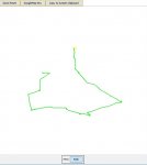
As you can see it's exactly the same shape as my previous Microsoft Excel attemp.
Only problem is route is not well oriented (it seems flipped on both axes)
By the way, Is there any chance showing a distance ruler in the window ?
My datGenericPlayers.pml bottom file is now this way:
It worked ! It is amazing ! Thanks a lot for your helpl
I got this plot into CsvView GeoPath window:

As you can see it's exactly the same shape as my previous Microsoft Excel attemp.
Only problem is route is not well oriented (it seems flipped on both axes)
By the way, Is there any chance showing a distance ruler in the window ?
My datGenericPlayers.pml bottom file is now this way:
Code:
<geoPlayer>
        <geopath>
            <name>AC</name>
            <symbol>A</symbol>
            <Latitude>IMU_ATTI(0):Latitude</Latitude>
            <Longitude>IMU_ATTI(0):Longitude</Longitude>
            <Altitude>General:relativeHeight</Altitude>
            <headingSignal>IMU_ATTI(0):yaw</headingSignal>
            <headingSignal>IMU_ATTI(0):magYaw</headingSignal>

        </geopath>
        <geoPath>
            <name>Home</name>
            <symbol>H</symbol>
            <Latitude>HP:Latitude</Latitude>
            <Longitude>HP:Longitude</Longitude>
        </geoPath>
        <geoPath>
            <name>MVO</name>
            <symbol>M</symbol>
            <Latitude>MVO:posY</Latitude>
            <Longitude>MVO:posX</Longitude>
        </geoPath>
    </geoPlayer>
Last edited:
I suspect that the orientation isn't flipped in both axes. It's rotated 180°. You can avoid this problem by launching with the Tello pointing true North.@BudWalker ,
It worked ! It is amazing ! Thanks a lot for your helpl
I got this plot into CsvView GeoPath window:
View attachment 1973
As you can see it's exactly the same shape as my previous Microsoft Excel attemp.
Only problem is route is not well oriented (it seems flipped on both axes)
By the way, Is there any chance showing a distance ruler in the window ?
My datGenericPlayers.pml bottom file is now this way:
Code:<geoPlayer> <geopath> <name>AC</name> <symbol>A</symbol> <Latitude>IMU_ATTI(0):Latitude</Latitude> <Longitude>IMU_ATTI(0):Longitude</Longitude> <Altitude>General:relativeHeight</Altitude> <headingSignal>IMU_ATTI(0):yaw</headingSignal> <headingSignal>IMU_ATTI(0):magYaw</headingSignal> </geopath> <geoPath> <name>Home</name> <symbol>H</symbol> <Latitude>HP:Latitude</Latitude> <Longitude>HP:Longitude</Longitude> </geoPath> <geoPath> <name>MVO</name> <symbol>M</symbol> <Latitude>MVO:posY</Latitude> <Longitude>MVO:posX</Longitude> </geoPath> </geoPlayer>
The GeoPlayer is based on lat/long coords. The MVO positional data is in meters I believe. So the GeoPlayer is being fooled into thinking the MVO data is actually lat/long data.
I'm involved in another (non drone) project for the next 6 to 9 months and don't have much time to implement new features. I'm just doing bug fixes and the like.
raulvolador
Well-known member
I suspect that the orientation isn't flipped in both axes. It's rotated 180°. You can avoid this problem by launching with the Tello pointing true North.
The GeoPlayer is based on lat/long coords. The MVO positional data is in meters I believe. So the GeoPlayer is being fooled into thinking the MVO data is actually lat/long data.
I'm involved in another (non drone) project for the next 6 to 9 months and don't have much time to implement new features. I'm just doing bug fixes and the like.
@BudWalker ,
I'm sorry you are so busy with your new proyects.
By the way, I'm pretty sure it's a flipping coordinates problem and not a rotation issue. See this another couple of samples: excel path vs GeoPlayer path. Is not possible match both routes by only rotation.

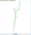
I tried to invert coordinates at datGenericPlayers.pml file using a "minus" sign at -MVO: posY, but it doesn't worked (CsvView didn't recognize symbol)
Code:
<geoPath>
            <name>MVO</name>
            <symbol>M</symbol>
            <Latitude>-MVO:posY</Latitude>
            <Longitude>MVO:posX</Longitude>
</geoPath>
I hope in a next future we can see Tello route path implemented into your great app.
Thanks a lot !
Raul
Last edited:
raulvolador
Well-known member
I got it !
It was so simple as swapping X and Y coordinates into datGenericPlayers.pml this way:
Path is now showed perfect. No flipped route anymore.
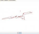
It's great !
Raul.
It was so simple as swapping X and Y coordinates into datGenericPlayers.pml this way:
Code:
<geoPlayer>
        <geoPath>
            <name>MVO</name>
            <symbol>M</symbol>
            <Latitude>MVO:posX</Latitude>
            <Longitude>MVO:posY</Longitude>
            <Altitude>MVO:height</Altitude>
        </geoPath>
</geoPlayer>
Path is now showed perfect. No flipped route anymore.

It's great !
Raul.
Last edited:
raulvolador
Well-known member
I have managed to show rulers over Tello's route map !
I have created a 40 meters ruler, and others of 100 and 200 meters long.
You choose show/hide rulers pushing buttons located bottom GeoPath window:
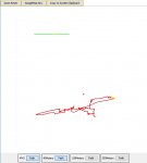
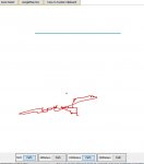
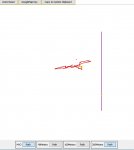
You only need editing CsvView/defs/datGenericPlayers.pml file bottom this way:
This way you can see route followed by Tello and calculate, approximately, its size and range.
Its cool !
Raul
-----
I have created a 40 meters ruler, and others of 100 and 200 meters long.
You choose show/hide rulers pushing buttons located bottom GeoPath window:


You only need editing CsvView/defs/datGenericPlayers.pml file bottom this way:
Code:
<geoPlayer>
        <geoPath>
            <name>MVO</name>
            <symbol>M</symbol>
            <Latitude>MVO:posX</Latitude>
            <Longitude>MVO:posY</Longitude>
            <Altitude>MVO:height</Altitude>
        </geoPath>
        <geoPath>
            <name>40Meters</name>
            <symbol>4</symbol>
            <Latitude>err_code:mag_stat</Latitude>
            <Longitude>IMU_ATTI(0):quatY</Longitude>
        </geoPath>
        <geoPath>
            <name>100Meters</name>
            <symbol>1</symbol>
            <Latitude>err_code:mag_stat</Latitude>
            <Longitude>IMU_ATTI(0):quatW</Longitude>
        </geoPath>
        <geoPath>
            <name>200Meters</name>
            <symbol>2</symbol>
            <Latitude>IMU_ATTI(0):quatZ</Latitude>
            <Longitude>err_code:mag_stat</Longitude>
        </geoPath>
</geoPlayer>
This way you can see route followed by Tello and calculate, approximately, its size and range.
Its cool !
Raul
-----
Well, of course they were switched. Sorry about that.I got it !
It was so simple as swapping X and Y coordinates into datGenericPlayers.pml this way:
Code:<geoPlayer> <geoPath> <name>MVO</name> <symbol>M</symbol> <Latitude>MVO:posX</Latitude> <Longitude>MVO:posY</Longitude> <Altitude>MVO:height</Altitude> </geoPath> </geoPlayer>
Path is now showed perfect. No flipped route anymore.
View attachment 1984
It's great !
Raul.
raulvolador
Well-known member
I posted an step by step video tutorial explaining how to show the Tello route in CsvView. You can see it here:
Plotting Ryze Tello Routes with CsvView
Plotting Ryze Tello Routes with CsvView
I hope you can help me.
I gave my son a Tello for Christmas. Firmware update, then calibrated and off on the fields for the first start, first start and only clicked on the button "Auto TakeOff", the Tello lifted a few cm from the ground and before I could take over the control, she went up into the air until the connection is broken and I could not see her anymore. After a few minutes I had another signal and got a picture where the Tello was about to land but couldn't see where it was and shortly after that the battery of the Tello was probably empty. I didn't find them anymore.
My hope was now by reading the log data from the Tello and your map to be able to determine the approximate location where I can search. I did everything to customize the datGenericPlayers.pml but don't get the buttons for the scales 40m, 100m and 200m displayed. Without the scale I have no orientation. I only see the button "MVO Path"? Do you have an idea?
Also, I'm not quite sure which "dat" file to take from the Tello Log folder. From the time of the first flight of the Tello I have three DAT files. With the largest DAT file it shows me only somewhere before Africa a start and an end point. The middle DAT file looks similar to your examples but the scale is missing. In the smallest file no GPS data is found and therefore nothing can be displayed in GeoPlayer.
Attachments
raulvolador
Well-known member
for sure i will help you as soon i came back home and be able to use my computer, maybe january 2.
all the best.
all the best.
raulvolador
Well-known member
Today I tried to read your LOG files into CsvView. I got this error messages from 1545821882163.DAT:
I don't know what is the problem. Sorry
GeoPath 40Meters has signal err_code:mag_stat that isn't defined
GeoPath 100Meters has signal err_code:mag_stat that isn't defined
GeoPath 200Meters has signal err_code:mag_stat that isn't defined
I don't know what is the problem. Sorry
Similar threads
- Replies
- 0
- Views
- 2K
- Replies
- 2
- Views
- 2K
- Replies
- 3
- Views
- 2K
- Replies
- 1
- Views
- 802
