I'd like to share with you this videotutorial explaining how-to plot Tello routes:
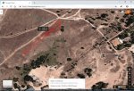
You can easily get route plots like this:

As you know, Tello Ryze uses an amazing Visual Positioning System.

An onboard camera into the aircraft belly and a lot of artificial intelligence make possible this little miracle. Tello can locate itself over the ground. Its position, speed and rotation is continuosly recorded and can be used for plotting a detailed map of your entire flight route.

During flight data is stored into a LOG file inside your mobile phone. First step is copy this file to your Microsoft Windows Personal Computer. You must use an Android File explorer app. For Tello app you must search into this folder: \Android\data\com.ryzerobotics.tello\files\droneLog\. If you are using aTelloPilot third part app you must search here: \aTelloPilot\Log
NOTE: It seems DAT files generated by stock Tello app do not work for this method.
For LOG file reading you need excelent CsvView aplication from BudWalker. You can contact him at [email protected]. I used version 3.6.1. CsvView download page
IMPORTANT: You have to manually edit <installationroute>/CsvView/defs/datGenericPlayers.pml file this way:
More details here: Drone log
Remember activate the "Invalid DatHeader OK" CsvView menu option
You can enjoy tello route into GeoPlayer windows. Use 40, 100 and 200 meters rulers for range estimation.

If you want to plot Tello route over a real map an aditional step is needed. As Tello's route is not geoferenced it has to be done manually. First, capture an screenshot of your flight zone on Google Maps, draw a reference ruler 100 meters lenght. Next step involves your favorite drawing aplication. Copy and paste Tello's route over a new layer and resize it until both rulers: map ruler an route ruler match. Then, rotate an displace route to your takeoff point and done !

Many thanks to @BudWalker for his excellent work
You can easily get route plots like this:

As you know, Tello Ryze uses an amazing Visual Positioning System.

An onboard camera into the aircraft belly and a lot of artificial intelligence make possible this little miracle. Tello can locate itself over the ground. Its position, speed and rotation is continuosly recorded and can be used for plotting a detailed map of your entire flight route.

During flight data is stored into a LOG file inside your mobile phone. First step is copy this file to your Microsoft Windows Personal Computer. You must use an Android File explorer app. For Tello app you must search into this folder: \Android\data\com.ryzerobotics.tello\files\droneLog\. If you are using aTelloPilot third part app you must search here: \aTelloPilot\Log
NOTE: It seems DAT files generated by stock Tello app do not work for this method.
For LOG file reading you need excelent CsvView aplication from BudWalker. You can contact him at [email protected]. I used version 3.6.1. CsvView download page
IMPORTANT: You have to manually edit <installationroute>/CsvView/defs/datGenericPlayers.pml file this way:
Code:
<geoPlayer>
        <geoPath>
            <name>MVO</name>
            <symbol>M</symbol>
            <Latitude>MVO:posX</Latitude>
            <Longitude>MVO:posY</Longitude>
            <Altitude>MVO:height</Altitude>
        </geoPath>
        <geoPath>
            <name>40Meters</name>
            <symbol>4</symbol>
            <Latitude>err_code:mag_stat</Latitude>
            <Longitude>IMU_ATTI(0):quatY</Longitude>
        </geoPath>
        <geoPath>
            <name>100Meters</name>
            <symbol>1</symbol>
            <Latitude>err_code:mag_stat</Latitude>
            <Longitude>IMU_ATTI(0):quatW</Longitude>
        </geoPath>
        <geoPath>
            <name>200Meters</name>
            <symbol>2</symbol>
            <Latitude>IMU_ATTI(0):quatZ</Latitude>
            <Longitude>err_code:mag_stat</Longitude>
        </geoPath>
</geoPlayer>
More details here: Drone log
Remember activate the "Invalid DatHeader OK" CsvView menu option
You can enjoy tello route into GeoPlayer windows. Use 40, 100 and 200 meters rulers for range estimation.

If you want to plot Tello route over a real map an aditional step is needed. As Tello's route is not geoferenced it has to be done manually. First, capture an screenshot of your flight zone on Google Maps, draw a reference ruler 100 meters lenght. Next step involves your favorite drawing aplication. Copy and paste Tello's route over a new layer and resize it until both rulers: map ruler an route ruler match. Then, rotate an displace route to your takeoff point and done !

Many thanks to @BudWalker for his excellent work
Last edited:
